Satellite Tracker API - Get Satellite Position Data in Real-time
Satellite Tracker API by Aviation Edge provides real-time satellite position data via JSON REST API. Find out more inside!

Aviation Edge is a global aviation API and database provider based in Europe with APIs on real-time, historical and future airport schedules, real-time flight tracking, autocomplete services, and much more.
#AviationAPI #AviationDatabase #FlightAPI
As Aviation Edge, our focus is aviation data but we do have one other passion. Our passion for space pioneers like SpaceX, ISS, NASA, and Virgin and the inspiring achievements of countries in the world led us to build the Satellite Tracker API. It is a JSON REST API that provides real-time position data plus static, general data for satellites and objects orbiting around the Earth. It is a pretty convenient REST API to track satellites based on a country, year, manufacturer, NORAD ID, and other details. Let's get to the details!

Whether you are looking for real-time satellite position data or general satellite data, you will find both in a standard Satellite Tracker API output. Here are the details included for each item in the response:
Satellite Code: NORAD ID code and international designator code. NORAD IDs are assigned by the North American Aerospace Defense Command organization for all man-made objects in Earth’s orbit. These are also called Satellite Catalog Numbers or USSPAACECOM object numbers.
Launch Date With Year: This is the launch date of the satellite in YYYY-MM-DD format. Launch year is also available as “LaunchYear”: YYYYY in case you'd like to filter satellites based on launch year.
Full satellite name: For example, “THOR ABLESTAR DEB”. (An American expendable launch system operated in the 1960s but still has a special place in my heart due to such a kickass name).
Launch number and launch part
Object Position: Real-time orbital apogee, perigee and period / Altitude, latitude, and longitude values / Orbit and right ascension.
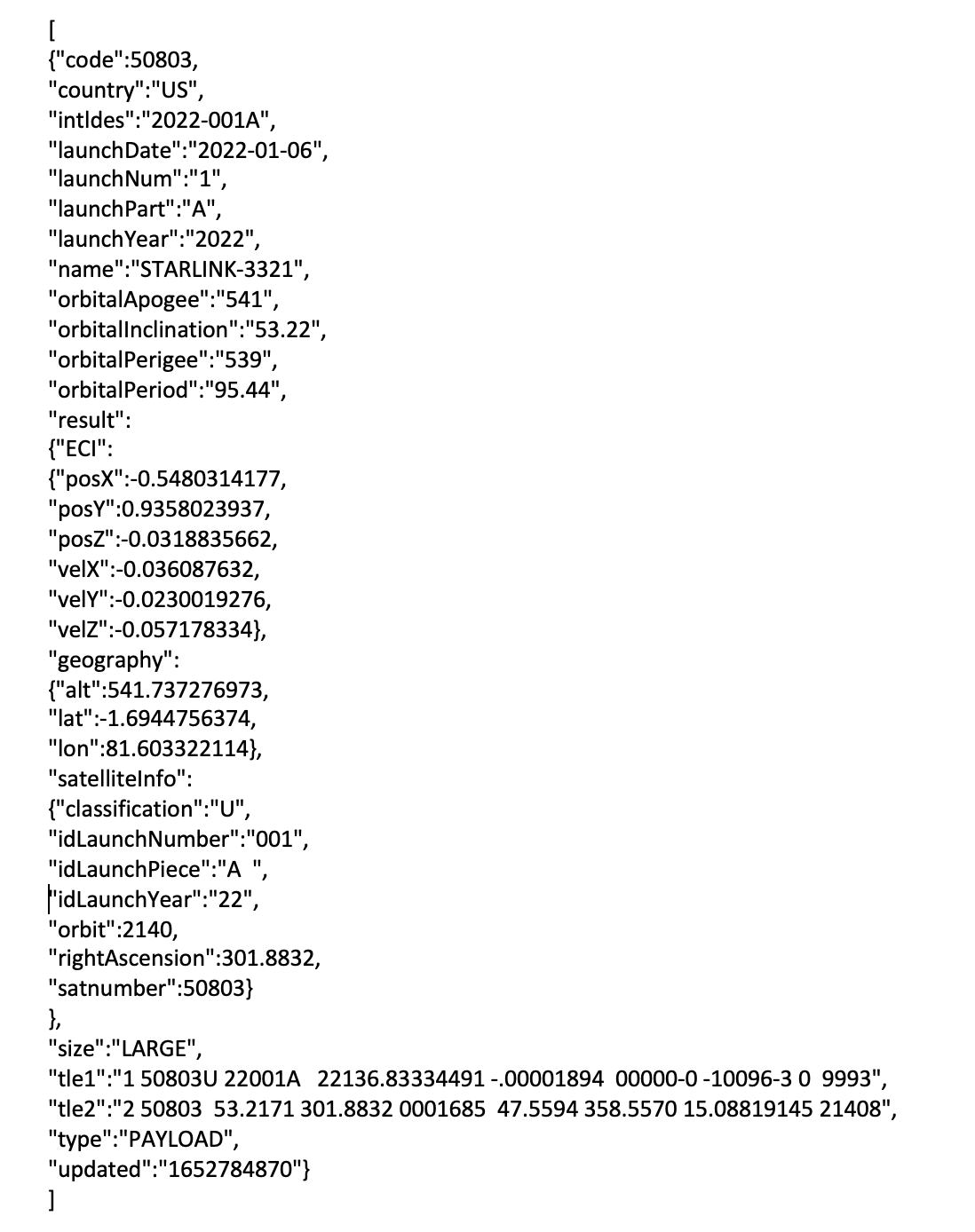
Position data can be a bit tricky to visualize if you are not very familiar with satellites. Please see below the example output for guidance or contact us!
ECI: Earth-centered inertial coordinates
Classification
TLE: Two-line Element Set (for more information on TLEs, you may visit our article below)
Satellite Tracking Data - Example Output
For Developers
Use-cases for a Satellite Tracker API are endless. We have clients using the satellite tracking data to build virtual 2D and 3D maps, satellite or ISS tracking apps for iOS and Android, make charts and analyses, do academic research, and more. This is why we wanted to add as many details as possible. This way, the API is built to cover any requirements you may have for the project you have in mind. As developers ourselves, we know that strong data is required for strong projects. Below is an example API output to help you visualize what you can do with the satellite tracking data:
The Satellite Tracking API is a JSON REST API with an average response rate of around 0.3 ms. The API is compatible with all major SDKs that come to mind, so the integration is pretty developer-friendly.
Track ISS, SpaceX Starlink Satellite Data, and Others via Satellite Tracker API
Not too surprisingly, ISS and SpaceX satellites are two of the ultimate client favorites to track. These space pioneers continue to make us curious about space with every new clue they find about space and new satellites they launch. The demand for online platforms where users can track these is also increasing. Just by taking a look at the Apple Store and Google Play Store, we can see many tracking apps that have the potential to reach a very good number of users and basically print money. This leaves one thing — finding the correct satellite tracker data provider. ahem.

Tip: You can make use of the real-time feature of the API to keep track of recently launched satellites and objects. By integrating the API, you can build 2D, 3D models and visual maps that show the movements of satellites around the Earth. For example, ISS and SpaceX Starlink tracking apps are a few of the user favorites and it is perfectly possible to build one with our API. Feel free to test the data now with greatly discounted prices and start off a few draft projects. Let the data inspire you!
Satellite Tracking API — Input, Output, and Filters
The Satellite Tracker API covers a huge number of satellites. As a result, filters matter. An optimal satellite API should be able to return to you the exact satellites you are looking for. Likewise, your platform should allow your users to track certain satellites.
Tip: It is possible to get all satellite and orbiting object data with a single API call. No matter how many satellites and objects are in the response, you can request them altogether by consuming only 1 API call of your monthly limit. Just keep in mind that since the data is real-time and is constantly updated, you would have to make a new API call to get the latest updated data.
Find out input and possible filters for the Satellite Tracking API on our full documentation or the API’s GitHub repo below. Need clarification on anything? Contact us and we'll get back to you.
Get an API Key for the Satellite Tracking API Right Away!
Feeling inspired already? Getting started is super easy by creating an API subscription here. Your API key and access to the data will remain active for as long as your subscription stays active. Simply purchase a key within a minute above and your API key with your dashboard login information will be automatically sent to your email. No further authorization is required. Upgrade, downgrade or cancel your monthly plan anytime with no commitments.
Have anything else in mind? Contact us about anything and our team will get back to you.

Follow us everywhere! %[https://linktr.ee/AviationEdgeAPI]

